

Analysis of Water Level Fluctuations and Implications on Local Livelihoods in the Great Rift Valley Lakes of Kenya | GreatLakes
Cooperating countries: Austria and Kenya
Coordinating institution: BOKU University
Partner institutions: Technical University of Kenya (TUK)
Project duration: 1 September 2021 - 31 August 2024
Budget: € 49.950,00
Project Summary
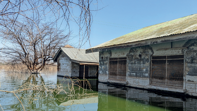
The Great Rift Valley Lakes of East Africa have recently experienced significant fluctuations in their water levels, affecting livelihoods of the local communities living within the riparian areas. Between the period of 2010 and 2013, increasing water levels in the Rift Valley Lakes of Kenya led to the expan-sion of Lake Bogoria, Lake Naivasha, Lake Baringo and Lake Nakuru by about 26%, 58%, 61%, 72% respectively. The consequent inundations from the expansions resulted into loss of productive agricul-tural lands often used for pasture and subsistent farming by the local rural communities. In some cases, the surrounding social infrastructure such as schools, dispensaries and hotels have been submerged and rendered inaccessible. These problems have been compounded in 2020 after an exceptional amount of above-normal rainfalls was witnessed for several months in the region.
This has called for renewed efforts on the need to undertake comprehensive studies to assess the water level fluctuations, also with a view to understand the causality. From the latest expert meeting held in Naivasha, Kenya in October 2020, it was noted that very limited information with regard to the flood inundations and flood risk consequent of water level changes exist. Furthermore, no compre-hensive hydrological analyses to detail the key water balance components contributing to the fluctua-tions have been carried out in the regions. Also, little attention has until recently been paid to the rising Lake levels and its overall effects, against the backdrop of other critical national issues that require more urgent attention from the meagre national resources. Nevertheless, such limitations only serve to jeopardize realization of not only the concerned National Goals, but also the Sustainable Develop-ment Goals (SDGs) related to Good Health and Well-being (SDG-3), access to clean Water and Sanita-tion (SDG-6) and realization of Sustainable Cities and Communities (SDG-11).
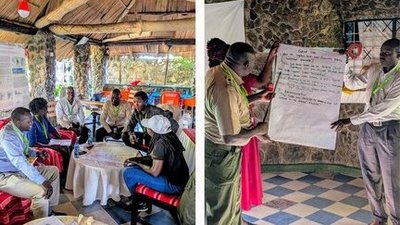
This study purposes to assess fluctuations in the water levels and their implication on livelihoods of the rural communities living around Lake Nakuru and Lake Baringo, which have been the most affected. A detailed hydrological analysis of the water balance components of the drainage basins feeding into the Lakes will be undertaken to provide an understanding of the potential causes. Analysis will be achieved with the support of satellite-based data sources, considering the eminent data scarcity of the region in overall. We envision a co-design, co-development approach beginning with a comprehensive need assessment involving targeted local stakeholders important to explore and contextualise the study objectives. The implications of the inundations on local livelihoods will be assessed through an assessment of the affected social infrastructures, farmlands, and the potential impacts on such activi-ties based on future scenarios.
To help achieve these objectives, while building the requisite human capacity at the same time, se-lected ongoing PhD students from the collaborating institutions will be partially sponsored, and in-volved in the data collection and analysis procedures. We specifically propose to support one ongoing PhD student based in Kenya, and one in Austria. During the project implementation, we purpose to hold workshops that will target the arising needs and gaps to be addressed by the involved stakehold-ers. A robust exchange of knowledge, skills and tools related to advanced analysis of global environ-mental challenges required at University levels is envisaged in the project framework, thereby improv-ing research capabilities and experiences of both institutions. We plan to organise a targeted University short-course that seeks to spread the acquired experiences horizontally to other ongoing postgraduate students at Kenyan institutions. Representative flood risk maps for localised applications will be devel-oped and provided to the relevant water managers in the study regions. Other results from the study will be disseminated through presentations and joint publications. The study will also provide a con-sistent database and new insights of the space-time Lake water level fluctuations important for sup-porting better regulation, development and management of the concerned land and water resources
Contribution to Sustainable Development
Significance of the study to local and national policy and in consequence also for Sustainable Development
The study will support local policy through the existing legislation within the Kenyan Government, thereby contributing directly to policy at local and national levels. This way, the results of the study will also be sustainable, based on legislation needs. The following existing legislations are relevant in the context of the proposed study:
- The Kenya Water Act 2016 (CAP 372) – Provide for the regulation, management and development of water resources, water and sewerage services including any other related purposes. The pro-posed study will support sustainable water resources management around the Lakes and up-stream areas of the draining catchments by providing data on hydrology, lake level fluctuations as well as extents of inundation.
- The Kenya Environment Management and Coordination Act, 1999 (CAP 378) – Law on environ-mental management and conservation. Although inundation and flooding may sometime have di-rect environmental benefits, it can however, on the extreme-end can result in to adverse environ-mental degradation through loss of infrastructure. The results will support frameworks for sustain-able restoration and further conservation of the damaged ecosystem and provide better guidance on easements to mitigate future impacts on critical infrastructure.
- The Kenya Public Health Act (CAP 242) – This law makes provisions for securing and maintaining a healthy nation through rules related to protection of public water supplies, general hygiene and in particular protection of food stuffs, diseases prevention among others. Because of the floodings, particularly of the settlements, increases in health risks from water borne diseases including con-tamination of drinking water systems/supplies are undisputed. The project will provide flood risk maps to guide protection of community water supplies and mitigate health risks from water re-lated disease outbreaks.
- The Kenya Land use and Physical Planning Act 2019 (CAP 286) - Governs matters relating to plan-ning, use, regulation and development of land in Kenya. The research will provide relevant infor-mation on flooding extent/potential inundation areas to support sustainable land use planning particularly for settlements and infrastructure to mitigate flood hazards.
- Kenya Vision 2030 and Kenya National Water Master Plan 2030 - A common roadmap vision pre-pared in 2007 as the country’s long-term development blueprint motivated by a collective aspira-tion of a better society by the year 2030. Reducing negative implications related on people and productive infrastructure is a strong part of Vision 2030. Through provision of information that can support effect on roads and infrastructure, we believe our study supports part of the economic and social pillars of the Kenya Vision 2030. On the master plan, the study will augment the existing plans for flood risks assessments and hazard expositions related to lake level rises, which are lim-ited at the moment.
- The Big Four Agenda – the country’s transformational blue print that is currently being imple-mented within five years (2017 – 2022) period. The agenda is designed to drive the Third Medium Term Plan (TMTP) for the Vision 2030. The agenda focusses on four pillars: Manufacturing, Food Security, Universal health coverage and Housing. Mapping of potential flood prone areas will en-sure proper land use planning both short-term and long-term, minimizing crop losses due to inun-dation of cultivated/agricultural areas and supporting sustainable food security as a pillar of the Big Four Agenda. Knowledge of floods and the associated hazards will assist in mitigating health risks from water borne diseases, a key contribution to the agenda on universal health coverage.
Relevance and linkage to the Sustainable Development Goals (SDGs)
The Lake level rises have led to loss of agriculture and pasture land, thereby having negative implica-tions on SDG 2 – Zero hunger: End hunger, achieve food security and improved nutrition and promote sustainable agriculture and meeting the targets:
- 2.1 By 2030, end hunger and ensure access by all people, in particular the poor and people in vulnerable situations, including infants, to safe, nutritious and sufficient food all year round
- 2.3 By 2030, double the agricultural productivity and incomes of small-scale food producers, in particular women, indigenous peoples, family farmers, pastoralists and fishers, including through secure and equal access to land, other productive resources and inputs, knowledge, financial ser-vices, markets and opportunities for value addition and non-farm employment
- 2.4 By 2030, ensure sustainable food production systems and implement resilient agricultural prac-tices that increase productivity and production, that help maintain ecosystems, that strengthen capacity for adaptation to climate change, extreme weather, drought, flooding and other disasters and that progressively improve land and soil quality
Submersion of health centres, increased risk of water borne diseases and the negative effects on the water supply jeopardize the SDG 3 – Good health and well-being: Ensure healthy lives and promote well-being for all at all ages, including compromising reaching the target:
- Target 3.3 By 2030, end the epidemics of AIDS, tuberculosis, malaria and neglected tropical dis-eases and combat hepatitis, water-borne diseases and other communicable diseases
Schools have been destroyed, leading to negative effects on SDG 4 – Quality education: Ensure inclu-sive and equitable quality education and promote lifelong learning opportunities for all.
The provision of clean water is hindered by contamination of drinking water sources. At same time, it is clear that the flooding, e.g. of pit latrines, will have negative effects on sanitation but will also have a negative feedback on the provision of clean water. “SDG 6 – Clean water and sanitation: Ensure availability and sustainable management of water and sanitation for all” is therefore also challenged in the affected areas. The flooding situation has aggravated the situation in meeting the following tar-gets in this context:
- 6.1 By 2030, achieve universal and equitable access to safe and affordable drinking water for all
- 6.2 By 2030, achieve access to adequate and equitable sanitation and hygiene for all and end open defecation, paying special attention to the needs of women and girls and those in vulnerable situ-ations
- 6.3 By 2030, improve water quality by reducing pollution, eliminating dumping and minimizing release of hazardous chemicals and materials, halving the proportion of untreated wastewater and substantially increasing recycling and safe reuse globally
In the current case no proactive management of the flood risks exist, i.e. no plans or maps exist to-wards an anticipatory risk management of further lake level rises. The sustainability of the communi-ties towards natural hazards are therefore obscured, leading to jeopardizing SDG 11 – Sustainable cit-ies and communities: Make cities and human settlements inclusive, safe, resilient and sustainable. The project clearly works towards achieving the following target:
- 11.b By 2020, substantially increase the number of cities and human settlements adopting and implementing integrated policies and plans towards inclusion, resource efficiency, mitigation and adaptation to climate change, resilience to disasters, and develop and implement, in line with the Sendai Framework for Disaster Risk Reduction 2015-2030, holistic disaster risk management at all levels
It is clear that the proposed study cannot provide all solutions regarding the above mentioned SDGs. With these myriad of issues, and to aid the current and future studies, we however aim to undertake a detailed situational analysis to summarize and provide a status quo of the current challenges. At the same time, we will propose and provide the appropriate training needs, including the tools and meth-ods befitting the study. The capacity building activities on University level, where future decision mak-ers, e.g. in the context of water resources or flood risk management, are trained, will provide sustain-able development. Only well trained personnel, e.g. working in the local administration or for local Water Resources Users associations and who are aware and able to apply potential tools and methods can provide solutions towards reaching the SDGs. This is especially the case, since the local contexts are to be considered very carefully.