Environmental assessment of the Vjosa riverscape as the basis for an integrated water management and sustainable catchment development | VjoSusDev
Project Coordinator: Sajmir Beqiraj
Coordinating Institution: University of Tirana
Partner Institutions: Polytechnic University of Tirana, Agricultural University of Tirana, University of Natural Resources and Life Sciences, University of Vienna, University of Innsbruck
Partner Countries: Albania
Project Duration: 1 May 2022 – 30 April 2026 (48 months)
Budget: EUR 518.687
Project Overview
The project seeks to establish a long-term continued research cooperation of Albanian and Austrian scientists in the field of water governance. The specific topic is a cooperative and interdisciplinary study of the Vjosa river system in Southern Albania – as the basis for its sustainable development. Through the application of remote survey techniques and modelling of hydrology, geomorphology, vegetation pattern and land-use of the catchment; a series of joint field missions and the establishment of a continued monitoring program the knowledge base for decision making and public and institutional awareness on water governance will be raised.
Reporting
VjoSusDev| Report on the 2nd project year | (May 2023 - April 2024)
The project period of the current reporting (May 2023 – April 2024) was successful in the integrative process of a large interdisciplinary research group as well as the dialogue between science, governmental institutions responsible for Water Resources Management and Conservation of protected areas and political decision makers.
A short list of key current project outputs:
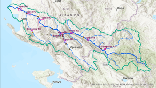
- Data collection and assessment on the ten river/floodplain reaches in the Vjosa catchment based on landscape and river-floodplain structures, in a discussion process with the all research teams. These representative reaches form the basis for a catchment wide evaluation of biodiversity patterns and ecological processes.
- Hydro-geomorphological assessment of reaches selected as basis for digital terrain models.
- Analysis of habitat distribution and habitat dynamics, habitat turnover rates over a 50- year series based on a series of satellite images from 1970 to 2022: The analysis of habitat turnover rates will provide the basis for analyzing the effect of habitat structure and habitat turnover on the specific biodiversity levels of the individual reaches.
- Analysis of five representative reaches including life history traits of characteristic floodplain species have been carried out
- Analysis of characteristic pattern biodiversity levels of aquatic fauna, meiobenthos, macrozoobenthos and fish over the whole river system with respect to characteristic life history traits
- A monitoring strategy for water quality analysis and groundwater ecology was developed.
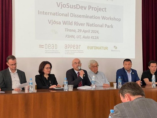
- A broad range of interactions and dialogues between research institutions, governmental institutions and decision makers have been developed (see Network concept in ANNEX III). A key contact and counterpart is AMBU (Agency for Water Resources Management), the governmental institution responsible for the development of the River Basin Management Plans (RBMP). Research plans and management relevant results were discussed with AMBU representatives during the project meetings and activities in Tirana, Tepelena and Vlora.
Environmental assessment of the Vjosa riverscape - VjoSusDev| Report on the 1st project year | (May 2022 - April 2023)
The project Environmental assessment of the Vjosa riverscape as the basis for an integrated water management and sustainable catchment development | VjoSusDev seeks to strengthen the research cooperation of Albanian and Austrian scientists in the field of water governance. It aims for a comprehensive understanding of the biodiversity and functional processes of the whole river system including its main tributaries as a basis for management. The project combines the research interests of 3three Albanian and three Austrian universities: it involves research teams on geomorphology, hydrochemistry, water quality assessment. vegetation ecology, groundwater ecology, macrobenthos, fish, terrestrial invertebrates and vertebrates.
The project focuses on four cross-cutting research topics, aiming for an interdisciplinary and translational character:
Work package 1: “Monitoring and understanding the fundamental physical regime governing the Vjosa riverscape” identifies the main physical processes. It is oriented towards a catchment-wide understanding of short-term and historical hydro-geomorphological processes as the framework for the characteristic biodiversity patterns and ecological functions.
Work package 2: “Maintaining the Vjosa riverscapes ability to support biodiversity” is accordingly aiming for a detailed understanding of the high and specific biodiversity of the Vjosa and its major tributaries.
Work package 3: “Ecosystem dimensions behind clean water provisioning, a key fluvial ecosystem service” is concentrating on limnological processes and water quality aspects.
Work package 4: „Science and Society interactions for sustainable development“ has a transdisciplinary and translational focus, bringing the research findings in the focus of governmental institutions, decision makers and the public.
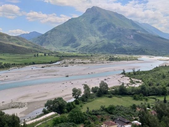
A main challenge at the start of the project was the selection a workable number of river reaches: 10 reaches of 1-5 km length were selected, representing the broad range of geomorphological characteristics and landscape ecological settings. The environmental and ecological features of these reaches will be studied by the different research teams at a range of scales - from reach scale (e.g. by e- DNA analysis) to microhabitat scale. The challenge will be to integrate and upscale the individual research efforts towards a broader understanding of the ecology of the whole catchment. This will be achieved by a formulation of joint research hypothesis and a continued interaction between the research teams.
The first year of the project from May 2022 – end of April 2023 was successful in starting the integrative process of a large interdisciplinary research group as well as starting the dialogue between science, governmental institutions responsible for Water Resources Management and Conservation of protected areas and political decision makers.
A short list of key project outputs:
- Delineation of 10 river/floodplain Reaches in the Vjosa catchment based on landscape and river-floodplain structures in a discussion process with the other research teams. These representative Reaches form the basis for a catchment wide evaluation of biodiversity patterns and ecological processes.
- Hydrogeomorphological assessment of Reaches selected as basis for digital terrain models.
- Analysis of habitat distribution and habitat dynamics habitat turnover rates over a 50-year series based on a series of satellite images from 1970 to 2022: The analysis of habitat turnover rates will provide the basis for analyzing the effect of habitat structure and habitat turnover on the specific biodiversity levels of the individual reaches.
- During the first year vegetation analysis of 5 representative reaches including life history traits of characteristic floodplain species have been carried out
- A first analysis analysis of characteristic pattern biodiversity levels of aquatic fauna, meiobenthos, macrozoobenthos and fish over the whole river system with respect to characteristic life history traits
- A monitoring strategy for water quality analysis and groundwater ecology was developed.
- A broad range of interactions and dialogues between research institutions, governmental institutions and decision makers (see Network concept in ANNEX III) have been initiated. A key contact and counterpart is AMBU (Agency for Water Resources Management), the governmental institution) responsible for the development of the River Basin Management Plans (RBMP). Research plans and management relevant results were discussed with AMBU representatives during the meeting at Tepelena (A. Miho, F. Schiemer, C. Hauer). Dialogue with AMBU, public hearings jointly the Ada program with Vjosa (Hauer)
PhD research on the Vjosa river
Meet APPEAR scholar Sonja Hoxha from Albania and learn about her research on last free-flowing, wild river in Europe. Read more